By Aditya Ramesh
Environment & History, essay no. 9
Our ninth contribution to our ‘Environment & History’ series by Dr Aditya Ramesh takes us back to waterways, this time in southern India. Reflecting on the historiographical positioning of the Cauvery delta, and new digital projects to map how it has changed over the long-term, Ramesh points us to the importance of understanding the wider socio-political landscapes created by the actual landscape.
By considering the colonial and post-colonial Cauvery he points us yet again to the power of conflicting interests, reminding us that these are often rooted in the successful adaptation to, and exploitation of, environmental change.
The next essay in the ‘Environment & History’ series will be published Wednesday 31 March 2021 with ‘Colonialism’s Climatic Legacies‘.
In a book now almost 25 years old, William van Schendel argued that the ‘three deltas’ of the Bay of Bengal, the Cauvery delta, the lower Burma delta, and the Bengal delta, prior to British colonialism, were some of the most fertile, rich, and oldest regions of human settlement in South Asia (Schendel, 1991). By the end of the colonial era, coinciding with the Second World War, these were increasingly impoverished spaces, but nevertheless of paramount importance to the food security of the region. Today, the changing climatic conditions in the Bay of Bengal – erratic monsoons, rising sea levels, and depleting water tables – threaten the food economies of these deltas, which have sustained human settlements across south and southeast Asia. As the Cauvery river, running over 700 kilometres from the Kodagu hills in south-eastern India runs into the Bay of Bengal, it splits into many rivers, creating a deltaic formation located in southwestern India (see figures 1 & 2).
The Cauvery (or Tanjore) delta has been shaped by its deep embeddedness over centuries within the rice economy. We can, however, think of deltaic landscapes in other ways, while acknowledging the importance of rice. The ecology of the delta is extraordinarily diverse, and here I focus on histories of labour, migration, salt, and silt. In thinking of the delta outside the dominant framework of rice, longer-term ecological changes come into view, shaped by new kinds of socio-political hierarchies. Furthermore, employing multiple methods, such as analysing long term weather patterns, maps, and walking with different communities and experts, offers a window into climatic and environmental change not as a grand narrative, but in terms of everyday resource-contestation.
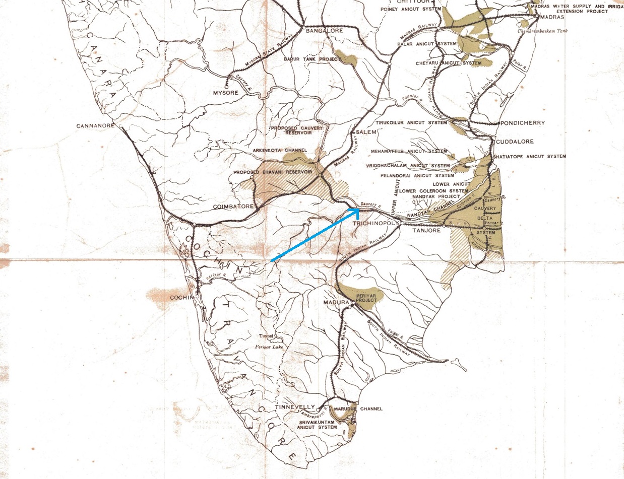
Figure 1 – Map of the rivers of South India, with the Cauvery river marked with a blue arrow, added by author. Source: Report of the Indian Irrigation Commission 1901-1903 (Government Press: Calcutta 1903).
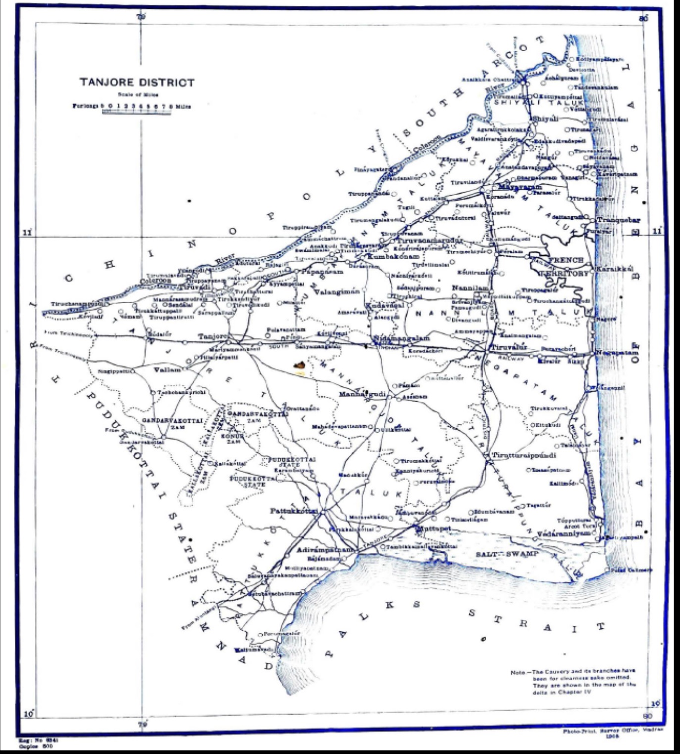
Figure 2 – Image of the Tanjore district, bordering the Bay of Bengal. Source: F.R. Hemingway, Madras Gazetteers: Tanjore (Government Press: 1906)
In the second century A.D, during the reign of the Cholas, the historiography of the Tanjore delta tells us about the close links between agriculture, state formation, and power. The Cholas is where the story of the Cauvery delta often begins. The Grand Anicut dam for instance, built by the king Karikalan, is not just important to archaeologists as evidence of civilizational presence, but to the fabric of economic life. This idea of marrying public works projects to state-making was continued by dynasties such as the Pandyas and Nayakkas. As I walked these landscapes, with Professor Y. Subbarayalu, an archaeologist and historian of Ancient south India, he explained that most settlements in the deltaic region are identified through temples and their water tanks, many of which still exist. Temples however, represented the upper-caste, and largely Brahminical view. Brahmins were given a share of the village produce, often deposited at the temple, the temple served as a site of deliberation of village affairs and was also the beneficiary of gifts from rulers and landlords. In this way, the institution emerged as a mitigator of ‘risk’, considering the unpredictable monsoon patterns in the Tanjore delta.
Irrigation and state power continued to have close links in the colonial era, albeit in new forms. In the 1960s, the World Bank economist, on the eve of India’s ‘Green Revolution’, Wolf Ladejinsky commented that Tanjore was ‘in almost constant greenery’. The green that Ladejinsky saw was lush rice fields. Much of the delta’s history is linked closely to the rice crop and water. Whether in Burma or in the Cauvery delta. British colonialism initiated new technological fixes, including canals, weirs, and dams to re-engineer various deltaic landscapes, including the Cauvery delta. Sir Arthur Cotton, the famous British engineer, whose statue still stands today in the Grand Anicut argued that to conquer the tempestuous Indian monsoon, large scale water storage reservoirs were critical. Cotton’s efforts were redoubled in the twentieth century, as British engineers turned their attentions to constructing dams across the head of the Cauvery. Damming the river, would finally allow for water to be released at will into the delta, and a degree of control over the tempestuous monsoon. The bedrock of these efforts to regulate water flows into the delta were about intensifying the commodification of its principal crop – rice. Evidence suggests that rice from the Tanjore delta was exported to Ceylon (present day Sri Lanka) at least from 1600.
By 1900, rice from the delta was shipped and transported across south India, but also faced increased competition from the newly established rice frontier in the Burmese delta. Culturally, rice, especially the polished variety, was in demand from the vast British bureaucracy, who preferred it to the local millet, Ragi, and demanded it as ‘payment in kind’. Therefore, the delta rice crop, despite facing this competition, and falling prices in the years of the Great Depression, persisted. In the years of the Second World War, when cheap Burmese rice was no longer available owing to the Japanese invasion of Burma, the Tanjore delta (among other deltaic regions) witnessed renewed interest as the ‘granary of south India’, culminating in the delta being chosen as one of the districts for India’s largest postcolonial experiment with food grains, the Green Revolution.
If canals and dams powered the rice economy of the Cauvery delta, the history of rice and the deltaic landscape was simultaneously one of power, caste, and labour. Land ownership, especially in the upper reaches of the delta, was largely in the hands of the mirasidars, who were large landowners responsible for cultivation and tax on behalf of a sovereign. On the mirasidars’ estates there were three types of cultivation: varam or sharecropping; kuthagai or fixed rent; and pannayal cultivation, by which a permanent labour force was tied either to the land or the landlord through coercion. The settlement report of 1805 claimed that nearly all the mirasidars cultivated their land using pannayals. Overwhelmingly, the mirasidars were from the Brahmin caste, who owned 25% of land in the district of Tanjore, while comprising of only 6% of the population (Menon, 1979). It was only in the postcolonial era that the state finally recognized the indiscriminate use of forced and bonded labour practices. Singling out the deltaic district of Tanjore, ‘The Tanjore Pannayal Act’ of 1952, identified, if somewhat half-heartedly, the uniquely discriminatory practices that prevailed in the district.
The dominant frame of understanding the delta, therefore, is that of rice, water, and canals. However, the delta is a far more diverse space, with unexpected and uncanny histories. From the 1820s, British rice, coffee, tea, and palm plantations across Ceylon, Malaya, and Burma led to the emergence of a new circuit of migration across the Bay of Bengal. The deltas of southern India, both the Cauvery and Godavary, with their stark inequalities and easy access to ports were prime sources for plantation workers, whose inhabitants crossed the seas in hope for a better future.
By the 1880s, the migratory system was so entrenched that a weekly steamer service ran across the coromandel coast, picking up maximum passengers in the deltaic port town of Negapatam (now Naggapattinam), on route to Penang, Port Swettenhamm and Singapore. Many migrants from these deltas returned home, following several years of working overseas. One story, for instance, is recorded of a woman from the Godavari delta, classified in colonial records as a ‘prostitute’, who migrated to Burma in search for work, returned, and built a temple worth GBP 3000, or Rs. 30,000 (All India Census report, 1872). Many who migrated were from the Dalit community, or the outcastes, who faced deep discrimination, and were often forced to labour on the fields of upper-caste landlords. A study of the Kshetralampuram village in the Tanjore delta in the 1930s observed that many who migrated returned after a few years of work. They brought back with them wealth and new ideas of living, with the study pointing out several houses markedly different from the rest in the village, built by returnees (Amrith, 2013). Another important circuit of migration from the delta to the city was of wealthy upper caste landlords – the Brahmins. The Brahmins accumulated capital in two ways; holding land as absentee landlords, while simultaneously becoming ubiquitous in the British bureaucracy.
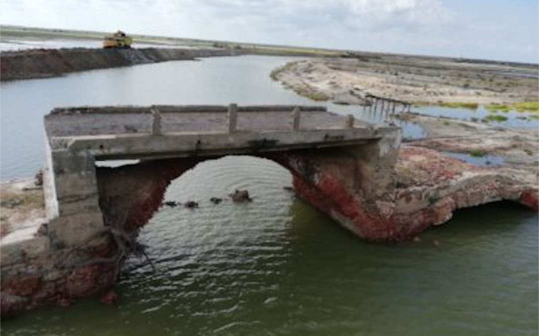
Further, beyond rice however, every ‘small space’ within the delta has different stories to tell. Take for instance the southern-most region of Vedaranyam, often the third category in British records, of the ‘salt swamp’ in the delta. Salt was produced in Vedaraniyam prior to colonial rule; used and taxed by the Maratha kings of Tanjore. In the colonial era similarly, the British government, while realizing that the salt produced at Vedaraniyam was too heavy for large scale commercial trade, sought to realize revenue from the swamp. The government, under the salt monopoly regulations, gave out licenses to those who wanted to manufacture salt, including the local temple at Vedaraniyam, who could manufacture salt once they paid excise duty on it.[1] However, the colonial government saw further economic potential in the Vedaraniyam region. The region was close to two ports, Topputturai and Point Calimere, the salt factory located close to the swamp, and home to many merchants. However, it lacked adequate transport to facilitate movement of goods and people to larger ports north of Vedaraniyam. In 1867, the provincial Madras government, at a cost of Rs. 55,000 finished constructing the Nagappatinam-Vedaraniyam canal, which ran along the coast from Vedaraniyam to the important port of Nagappatinam, for 35 miles (see figure 3).[2] The canal was designed to transport boats and merchants, and the goods transported consisted of firewood, manure, charcoal, straw as well as salt.[3] Gradually however, roads that connected Vedaranyam and Naggapattinam, as well other modes of transport such as the railways, ‘the importance of the canal as a means of navigation declined.’ (Public works department 2016, 4)
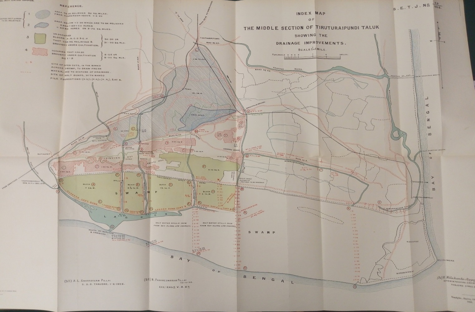
Figure 3 – Image of the Vedaranyam canal, in the Tanjore delta. G.O. No. 141 I., 28th May 1928 (Public Works Department). India Office Records/P/11690.
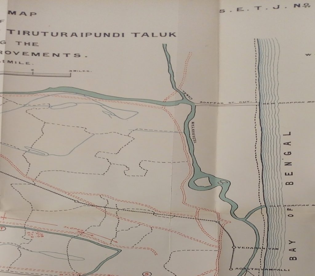
Figure 4 – A close up of the straight cut.
There is a parallel history of the Vedaranyam canal and its relationship to the inlet of salt water, from the swamp and the sea to the inland regions. The flood waters of the canal drained into the Bay of Bengal sea through six ‘straight cuts’. While the flood waters entering the Vedaranyam canal were to be drained through straight cuts to the sea, there were several issues. As the canal slowly declined in use, the cuts, over the decades, were badly maintained. Therefore, sand bars formed at the edge of the cuts, and silt began accumulating within the inlet. When floods occurred, as they frequently did during the northeast monsoons, water levels in the canals rose, but with nowhere to drain on to. Over several decades of neglect meant that the low-lying lands near the salt swamp were inundated, and being close to the coast, the freshwater canal began to slowly transform into saltwater lands.
New digital mapping projects have illustrated this longitudinal change. A partnership between the National Library of Scotland and Dr. Deborah Sutton shows how detailed Survey of India maps can be overlaid, using geo-referencing techniques, on to a contemporary ESRI world image background. The map I have examined is the standard topographic series map created by the Survey of India (south India only) using the scales half-inch to the mile (1:126,720), for the years 1916-1932. Even a cursory study of the map shows the extent to which the salt pan regions have expanded into new territories, but not as swamp, but rather as a built type of farm. However, at least to a non-remote sensing specialist, the change is clear to me when I walked the landscapes of Talainayar, a region where shrimp farming in salt water has encroached formerly agrarian regions. I fully understood the scale of change through methods such as the walking the terrain and long interviews with people living in region. While digital maps and the data they present are invaluable, the precise ways in which these changes are occurring is a deeply social process, one which requires careful mapping.
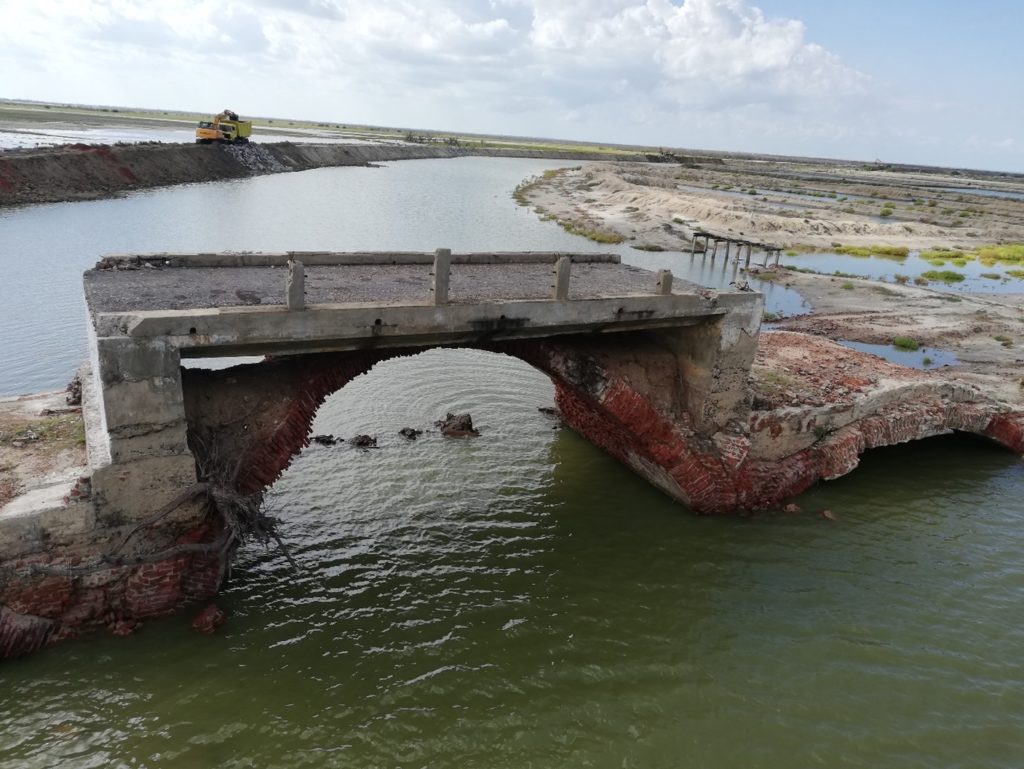
Figure 5 – Shrimp farms in-construction in Talainayar. Photograph by Aditya Ramesh, 4.10.2019.
Similarly, thinking of the longer-term consequences of British colonialism, silt plays an important role. British deforestation, and canal and dam building, while adding immensely to the colonial and postcolonial economy, are confronting the ecologically precarious present. In the 1850s, as floods struck the Tanjore delta repeatedly, an investigation was carried out into whether the floods were a consequence of deforestation on the hills, and subsequent water run-offs. The British geographer, Clements Markham (1866) wrote, ‘It must be remembered, however, that the destruction of forests is far from having reached its limit, that the rapid surface drainage caused by it already effects much mischief in the hill-districts, and that, as the felling proceeds, these consequences may eventually be felt even in the Cauvery delta. A recent study points to how the Mettur dam, constructed in 1934, has prevented silt deposits into the Cauvery delta. Even as early as 1906, the construction of a complex system of anicuts had led to decreasing quantities of silt available for manure. Rather than water and silt running freely into the lowland region of the delta, the dam has blocked the silt at its head. This according to Professor S. Janakarajan, contributes to the sea slowly making inroads into the delta regions nearest to it. New digital history projects aim to map these ecologically complex deltaic lands, allowing us to visualize change over long timeframes.
Therefore, the legacies of colonial techno-fixes have had a long reach on the Cauvery and other deltas in south India. The ecological impacts, while hinted at by colonial contemporaries, were hardly anticipated, or fully understood at the time, pointing to the importance of writing longer histories. Digital maps and data on silt for instance are evidence that ecological degradation has been a slow and on-going phenomenon, one that is easier to identify in the present. Yet, this degradation is inextricably tied to power relations in the Cauvery delta. The shrimp from the multitude of farms, for example, which have taken advantage of increasing salinization in the delta, are sold as far away as Europe. They are owned by politician-capitalists, who have actively dispossessed Dalit landholders at the edge of the delta, who gained access to land rights through struggle and legislation in the 1980s. In the face of saline incursion, these lands become worthless for agricultural purposes, forcing communities to work as labourers on shrimp farms. Any kind of ecological restoration/protection then, must come from a position to de-stabilize the power of those who have accumulated using degradation. Understanding how that accumulation has occurred and figuring multiple possibilities of emancipating land, labour, and ecology together is therefore vital to our environmental futures.
References
- Tanjore District Gazeteer (1915), 195-196.
- Tanjore District Gazeteer (1906), 4.
- Techno-economic Survey of Madras (Madras 1960), 165.
***
Dr Aditya Ramesh is Presidential Fellow in environmental history at the University of Manchester, focusing on dams and expert knowledge in colonial and post-colonial India, deltaic environments, and urban ecologies. Ramesh was a postdoctoral fellow in the Prediction, Emergence, Adaptation and Knowledge (PEAK) Urban GCRF project at the Indian Institute for Human Settlements, before joining Manchester’s Centre for the History of Science, Technology and Medicine, with a ESRC postdoctoral fellowship in 2019 (Proj. ref.: ES/T006196/1), when the fieldwork for this article was completed. His article ‘INDIAN RIVERS, ‘PRODUCTIVE WORKS’, AND THE EMERGENCE OF LARGE DAMS IN NINETEENTH-CENTURY MADRAS’, which lends context to this article, was recently published in The Historical Journal.