By William D. Shannon
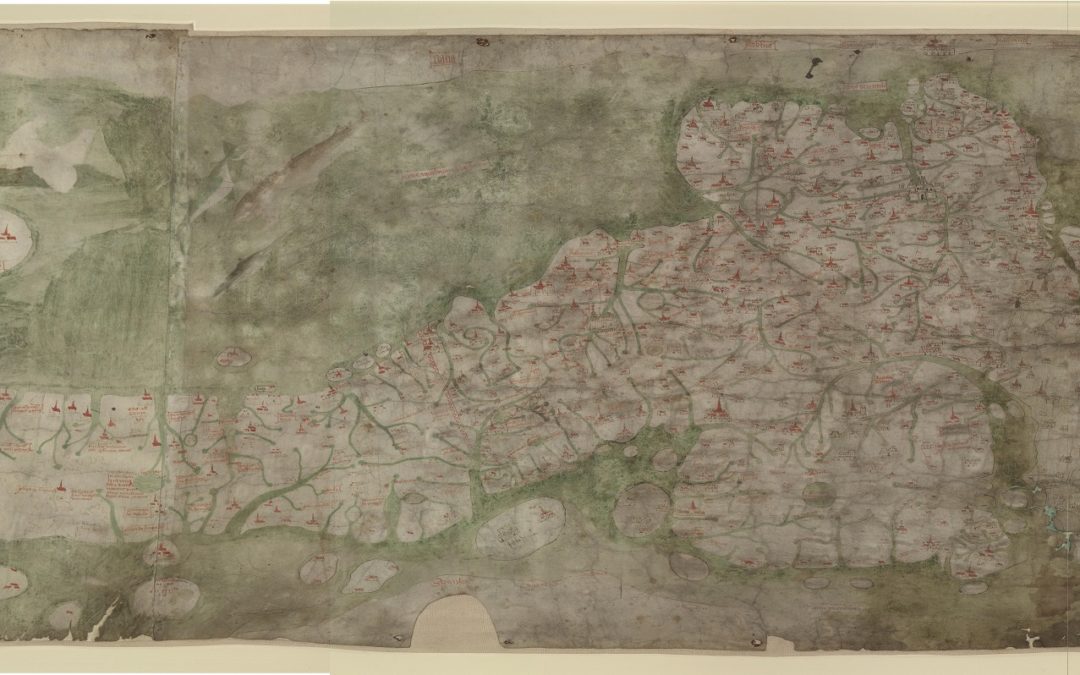
The Gough Map Project has reached that ‘interesting’ stage where we are moving from either sitting on the fence and making no decisions, or making lots, but then rejecting them all. It is now time to reach some firm conclusions, and start writing. The Project has been funded by Leverhulme Trust (RPG-2019-070) for the last three years, but started in 2012, when IHR Senior Fellow Catherine Delano Smith, the doyenne of map historians and long-time editor of Imago Mundi, the international journal for the history of cartography, decided that the only way to tackle the enigma that is the Gough Map was to throw people at it in a way that is normal in the sciences, but most unusual in the humanities. Over the years, some three-dozen people from a variety of disciplines have been involved, including hyperspectral analysts, Raman pigment analysts, specialists in 3D scanning, palaeographers, philologists and place-name specialists, mediaevalists, map historians, and regional historians, all trying to get to grips with a rather worn, rectangular piece of parchment, just over a metre across, which Richard Gough had bought for 2s 6d back in 1774.
As soon as he saw it, Gough knew it was something special. He had it engraved for his British Topography (1780), writing that ‘the greatest merit of this map is, that it may justly boast itself the first among us wherein the roads and distances are laid down’. A hundred years later, a facsimile was issued by the Ordnance Survey (1871), with W.B. Sanders dating it to c.1300, and repeating Gough’s statement about its ‘greatest merit’, but also drawing attention to many of the extraneous features of the map, including a shipwreck scene, which he thought depicted the last voyage of the “Maiden of Norway”, (1290). He was also the first to notice the pinholes (of which more later), which he supposed to have been made by Gough’s engraver. Surprisingly little attention was then paid to the map for more than half a century, until a new facsimile was published in 1958, with an account by E.J.S. Parsons of the Bodleian, who concluded it was ‘an official compilation’ dated to c.1360, and that ‘there is no doubt that its purpose was to serve as a map for travellers’.
And there the story rested for another half-century, until Nick Millea in 2007 issued what he described as ‘very much a reworking of Parsons’ classic’. However, a challenging question-mark at the end of the subtitle—‘The Earliest Road Map of Great Britain?’—hinted it was time for a reappraisal. Just prior to this, contradicting preceding opinions, Daniel Birkholz had suggested the map was produced as an object for display, to make a statement that ‘Britain is a single monarchy of the whole island’. Around this time, a series of papers began appearing in Imago Mundi, throwing up new ideas about the map: and in 2011 the Bodleian published a digital version of the map, making it readily accessible.
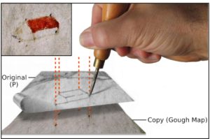 Much of the work so far had looked at the map as a text; but from its inception in 2012, the Gough Map Project adopted a new three-way approach, looking at it as ‘Artefact, Image and Text’—and taking both a ‘bottom-up’ and ‘top-down’ stance. The former involves more than a dozen regional experts, each taking a forensic look at the places depicted. The latter led to perhaps the biggest break-through, when scientific analysis of the map revealed the extent of those pinholes: it was now clear that, far from being the engraver’s work, they showed that ‘our’ map is in fact a copy of an earlier map, made by laying the Predecessor map on top of a new piece of parchment or, rather, two skins stitched together so as to be the required size. The map-maker had then used an awl or parchment-pricker to transfer enough of the outline of the settlement signs from the old map to indicate not only the location but also the nature of each (small or large, with or without a tower. etc). But not every settlement on ‘our’ map has pin pricks, suggesting that ‘our’ map was consciously updated from the Predecessor, not just blindly copied. Moreover, it became clear the Gough map itself was not a static object, but had gone through several revision stages.
A 2015 symposium held at the Bodleian heard a dozen speakers reveal numerous new insights into the map: which led in turn to an interim paper in Imago Mundi in 2017, entitled ‘New Light on the Medieval Gough Map of Britain’. Since then, the work has continued, with the realisation that, although we are all standing on the shoulders of those who have studied the map over the last 250 years, much of what has been concluded about the map has been to a greater or lesser extent wrong! We are dealing with not just one map but two: the physical map, and the ‘ghost’ map, which lies behind it and which we are only beginning to come to grips with.
And so, we now have still more questions as we turn over the possible scenarios. If the copying was done in the early years of Henry IV, when was the Predecessor made? And where? And why? And why was our copy made—and where? And, what about that shipwreck? And, especially, what about those red lines previously interpreted as “roads”: it seems quite clear that these were not on the Predecessor, which means it never was a road map. Indeed, as we have progressed, we have realised those red lines are, at best, routes. Despite Parsons’ assertion about serving travellers, the purpose of the red lines seems to have been primarily to help the map-reader understand what was still, at the beginning of the 15th century, largely a wholly unfamiliar piece of technology: a regional map. A final round of scanning by the scientists, with new equipment and programs, may—or may not—help with the answers. But one thing we feel sure of: Mr Gough’s map was never a high-quality, show-piece display object; it was a back-room, practical, work-a-day thing.
Over the last two years, prevented by lock-down from meeting in person, we have come to realise that Zoom has enormous advantages for a team project like this, as we share our screens and pore over the detail of the map in a way which would be impossible in a physical meeting. As ideas spark from the attendees, consensus starts to emerge around some tentative answers to that long list of questions about the map, its Predecessor, and its derivatives. But for those answers, I’m afraid you will have to await a couple of years for the publication of the book, which will coincide with the 250th anniversary of Mr Gough’s purchase. And that takes us back to where I started: it’s now time for the team to firm up on the decisions and start writing.